John Adams Way at 40 '“ an illustrated history


The £1m project, designed to ease traffic congestion in the town, was more than two decades in the making.
It dramatically changed the landscape of the town, with homes and businesses demolished and roads cut in two or lost entirely.
Advertisement
Advertisement
As part of the build, the green light was even given for human remains to be disinterred from a chapel burial ground to make way for the road.
For the lifetime of the project and even in the months after John Adams Way had opened, it was referred to as the ‘inner relief road’ – this was despite it being named John Adams Way at a meeting of Boston Town Council five years earlier.
To mark the road’s 40th anniversary, we have trawled the archives to put together this long and winding history of a relatively long and somewhat winding road ...
* The 1950s
The story of John Adams Way can be traced back to at least the 1950s.
Advertisement
Advertisement
In September 1961, The Standard wrote of the inner relief road in its Topical Talks column: “We first heard about this plan, designed to relieve traffic congestion in the town, as far back as 1956. At the end of that year a public inquiry was held into the proposed route of the road. Three years later – yes, three years – the Minister of Transport’s decision was announced. Or rather, it was a half decision, for a bridge over the Haven was approved and the southern half of the road’s route was agreed. But the northern half, from Spain Lane to wherever in Wide Bargate the road was to emerge was left high in the air.”
However, a town council debate in January 1962 suggests the plan predated 1956.
Coun N. H. Middlebrook said: “In 1945, the council’s policy was that they wanted a bypass road, but this idea was abandoned in 1952, and an inner relief road preferred.
“We have still not got it. When we are going to have it, I don’t know. There is no date, the scheme is just some time in the future. We may have to wait for years.”
He was right – 26 years ... and four months.
* 1961
SEPTEMBER
Advertisement
Advertisement
A public inquiry was held into the last half of the inner relief road’s route.
The Ministry of Transport’s suggestion was that it should link up with Bargate Bridge after passing through Cheyney Street, Chapel Row, Main Ridge, Boston Bowling Club’s bowling green (to some upset to the club), Peacock Hotel yard, Shodfriars Lane, and South Street.
Alternatives were proposed including one which would have gone through the football ground.
The Standard wrote, prophetically, in its Topical Talks column: “Progress is sometimes achieved by leaps and bounds. And sometimes it becomes so painfully slow as to be scarcely perceptible. Into this latter category, we fear, has crawled the proposed Boston inner relief road.”
* 1963
MAY
Advertisement
Advertisement
Boston was not likely to see its planned inner relief road for at least 10 years, the Standard reported.
Ald Valentine, Highways Commitee chairman, told members of Boston Town Council: “No one has pressed harder for this road than the borough surveyor and my committee. But the Ministry has definitely told us very firmly that we can forget about it for 10 years at least.”
In terms of the town seeing the road, he was right – it would be another 15. However, some progress was made earlier than that ...
* 1965
The decision was taken to build the inner relief road and its route is settled.
* 1966
JULY
Advertisement
Advertisement
The first phase of the inner relief road was completed with the opening of the new Haven Bridge.
* 1969
The county council accepted the assignment to design the inner relief road on behalf of the Department of the Environment, with the agreement of Boston Corporation.
* 1972
OCTOBER
Department of the Environment officials explaining plans for Boston’s inner relief road at a public meeting are urged by Ald George Whitehead, chairman of the town’s Highways Committee: “For God’s sake, get on with it.”
Representing the corporation, he said: “For years some kind of scheme like this has been envisaged, and proposals have sterilised property in the area.
Advertisement
Advertisement
“Now we know what you are going to do we are delighted with the proposals, for they will enable us to consider other schemes for the improvement of the borough.
“My only plea is that there shall be no further delay.”
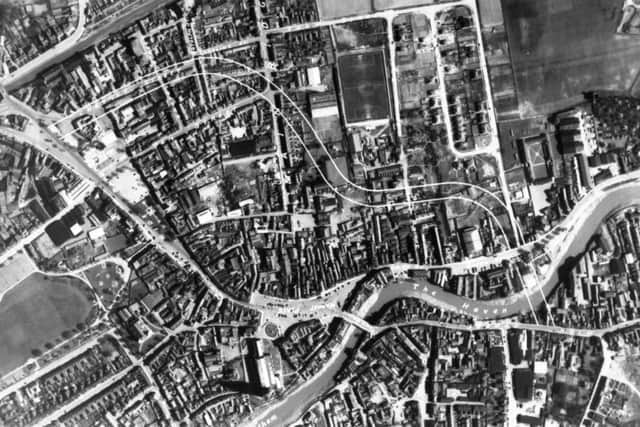
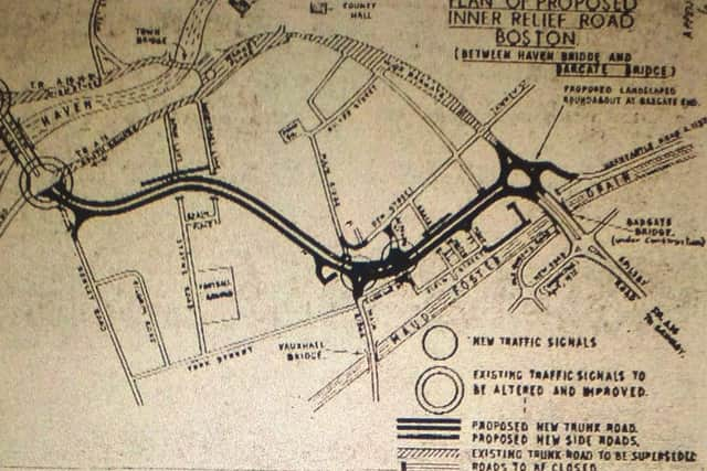
The plan comprised: a thousand yards of dual carriageway across land, much of it derelict, between Haven Bridge and Bargate Bridge.
Diversions, alterations, and stopping-up of side roads would be involved.
Existing traffic lights at Haven Bridge would be re-phased and the road would finish at Bargate End by means of a landscaped roundabout.
Advertisement
Advertisement
There would be traffic lights near its middle at the Main Ridge and the Botolph Street junction.
At that time, it was hoped the road would be open by 1975.
* 1973
APRIL
The second phase of the inner relief road was completed with the opening of Boston’s widened Bargate Bridge.
The third and final phase, the construction of the road itself, was now hoped to be complete by 1976.
APRIL
John Adams Way was chosen as the name of the planned inner relief road.
Advertisement
Advertisement
The Town Council made the decision to commemorate the man who was second president of the USA and the Republic’s first ambassador to this country.
Coun Bruce Veal said he doubted whether any councillors apart from the Highways Committee – who had recommended the name – would know who John Adams was.
“I think we should call the road something that will have significance to the people of Boston,” he said. “To inflict the name John Adams, which will mean nothing to anyone here, shouldn’t even be considered.”
Coun Veal explained that John Adams was one of the names suggested for the road by the American Embassy.
Advertisement
Advertisement
He said that another of the Embassy’s suggestions – Boston Post Road – would be more appropriate.
The name exists in the Boston area of the States, he said, and the name signifies a quick passage from one area to another.
His amendment for the name to be adopted was lost.
Ald G. G. A. Whitehead, chairman of the Highways Committee, said that he had not known the significance of John Adams’ name when it was first suggested. If the name was adopted other people too might learn something of America’s history, he said.
Other new names were Puritan Lane for the access to the Old Drill Hall and Quaker Lane for a new road from Shodfriars Lane to a car park.
AUGUST
Advertisement
Advertisement
Boston’s planned inner relief road must be built as soon as possible if the town’s character was to be preserved.
This was the view of the borough council, given by borough surveyor Ivan Stimson at a two-day public inquiry into John Adams Way’s side roads and junctions.
Environmental damage resulting from heavy traffic through the town centre was eroding its character and environmental characteristics, he said.
It was estimated 17,360 vehicles would use the new road per day. By 1990, so-called the ‘Design Year’ for the route, more than 26,000 vehicles were expected to use it. (Traffic studies in 2013 gave it as 17,555 vehicles southbound, and 21,853 vehicles northbound).
Advertisement
Advertisement
On the subject of properties being demolished for the build, Mr G. S. Sellars, of the Roads and Transportation section of the Department of the Environment, said the avoidance of property was of ‘paramount importance’ in the plan.
“This is shown by the somewhat devious route of the road, and the adherence to existing highways,” he said.
* 1974
APRIL
Human remains were to be disinterred to make way for the inner relief road, it was reported.
The planned route for the route would cut across part of the Unitarian Chapel’s burial ground in Spain Lane.
Advertisement
Advertisement
Skeletons, along with headstones, and other monuments, would be moved round to the east side of the chapel.
SEPTEMBER
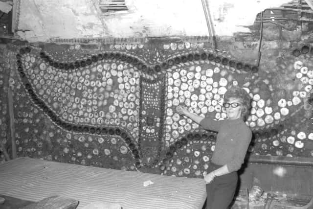
A final attempt to save the ‘Whale’ public house in Main Ridge, Boston, had failed with the news that Boston Preservation Trust would not support a move to stop its demolition.
The ‘Whale’ including the unique Whale Room was due to be demolished for the inner relief road.
The room was built by a Boston man in 1847 to house a whale’s skeleton. Nothing of the whale remained, but various impressions including that of a whale’s tail and an elephant were made out of shells in the walls.
Advertisement
Advertisement
Mr C. R. Theobald, secretary of the trust, said: “It is regrettable but we can not see any grounds on which to object to the demolition. We feel that the public interest is better served by the ring road.”
DECEMBER
Approval was given at a public enquiry to widen Craythorne Lane, near Boots, to allow for access to properties to its rear cut off by the proposed inner relief road. The move proved highly controversial, though, attracting staunch opposition, and the idea was dropped.
* 1976
MAY
A tender of £624,500 was accepted for work on the inner relief road, due to start that month.
The successful business was Sheldon Contracting Co Ltd, of Solihull. Theirs was the lowest of the five tenders received.
Advertisement
Advertisement
It covered the whole of the roadworks, except for the provision of traffic signals and street lighting.
AUGUST
Pottery dating from early medieval times, large quantities of medieval boots and shoes, glass, and a lot of animal bones had been found in The Bar Ditch – a drainage system dating back to the Middle Ages.
Some 170 metres of the ditch had been uncovered at the back of Pilgrim Road on the site of the new road.
The ditch was once the foul drainage system of the town. At every high tide the river would flush it out.
NOVEMBER
Advertisement
Advertisement
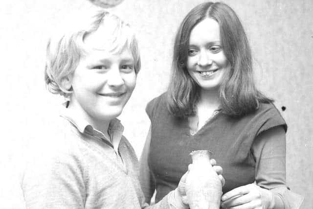
The Standard reported on a 12-year-old schoolboy who had found the only whole pot recovered from the Bar Ditch since excavation work began in the summer.
Kitwood’s Paul Holland, of Spain Lane, was playing with a pal on the excavation site when the pot – thought to be late 13th century – became unearthed.
“I washed it in a puddle and realised it was old,” said Paul. “So I took it to the Guildhall Museum to see if they could value it.”
* 1977
JANUARY
Residents in Botolph Street had spoken out over disruption caused by the construction of the inner relief road on their doorstep.
Advertisement
Advertisement
“It’s dreadful trying to live here while all the work is going on. You can’t keep carpets clean because the street is so muddy,” said Daisy Russell.
FEBRUARY
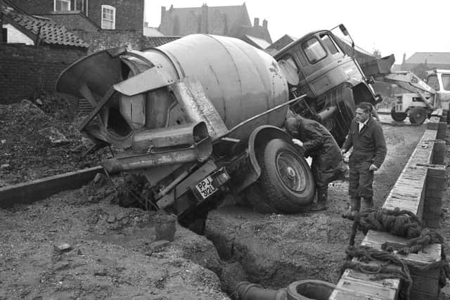
A lorry and its load of ready-mixed concrete looked set for a sticky end when a back wheel lodged itself in a trench during work near what is now Quaker Lane.
FEBRUARY
Parts of the inner relief road came into use as a diversion while work took place to surface the new carriageway between Main Ridge and Grove Street, the Main Ridge/Pen Street slip road, and the new section of Botolph Road.
The rest of the road from Main Ridge towards Haven Bridge was still not open to traffic.
Advertisement
Advertisement
Something similar would happen the following December due to resurfacing in Wide Bargate.
MARCH
A slip road from John Adams Way was proposed to keep access for properties cut-off by the road rather than widening Craythorne Lane or, the latest proposal, using Spain Lane.
Councillors and officials watched two large lorries driving in and out of Spain Lane onto South Stret. To negotiate the bend, the lorry had to mount the pavement and both vehicles had to edge slowly round to avoid hitting the walls on either side of Spain Lane.
MARCH
Hotel landlord Harry Pelling claimed his takings had dropped by £125 a week since work began near his property on Boston’s inner relief road.
Advertisement
Advertisement
In addition, he blamed recent damage to the building he spent £3,000 on improving the previous year on vibrations from equipment being used on the site.
Mr Pelling, who took on The Ram Hotel, in Wide Barate, on a 10-year lease in January 1976 said floorboards in one bedroom had sunk by eight inches in places, stair treads were coming away from the wall, and cracks were appearing in newly decorated rooms.
APRIL
The original contract figure for the inner relief road of about £624,000 was expected to have risen to £744,000 due to delays. Every added week was costing £4,000 to the project, Coun Jack Parker told the Environment Committee.
AUGUST
Landlord of the Red Cow Hotel, in Wide Bargate, Boston, Francis Mohan, claimed his business had been cut heavily since the car parking was taken from the front of his pub.
Advertisement
Advertisement
Mr Mohan said he thought the hotel had great potential when he took over almost a year earlier.
The road outside The Red Cow was part of that which was being taken to create a large new traffic island at what would become the junction of the inner relief road with Wide Bargate.
NOVEMBER
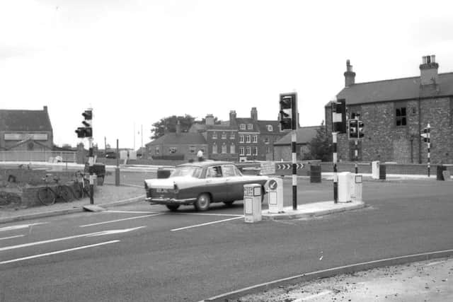
A major step in the progress on Boston’s inner relief road was taken when traffic started using the new roundabout at Bargate End.
Although it was restricted to one lane, the move gave drivers their first taste of negotiating the new arrangements and discovering the new signs.
Advertisement
Advertisement
One of the most significant changes was the blocking off of Horncastle Road at Bargate Bridge and the subsequent diversion of traffic round a slip round.
NOVEMEBER
The Standard in its Opinion column cast doubt on how smoothly traffic would flow down John Adams Way opened, but also speculated on how much better life might be like in a traffic-free Strait Bargate.
“That magnificent mile with its broad carriageway and sweeping concrete curves, the Boston inner relief road, conjures up visions of a super speedway. But in practice, the picture will disappear like a mirage for, especially at times of peak pressure, it will be illusory.
“... as though traffic density will not of itself be enough of an obstacle, there are to be several sets of traffic lights controlling highway intersections and pedestrian crossing points. So it can safely be assumed that, between Haven Bridge and Bargate Bridge, speed will be out and stops in.”
Advertisement
Advertisement
“There will, however be advantages in the scheme. There will for instance be no more shoulder nudges for pedestrians in the narrow Strait Bargate, which will be by-passed by the new road, and no more hats will be dislodged by lorry mirrors protruding over the pavements. And think for a moment of what could replace the current confusion, chaos, and danger of this old bottleneck. Think of a warm, sunny summer’s day, and Strait Bargate one vast pavement from shop window to shop window, with seats and benches and perhaps a sculpture or two in the middle.
“Test your imagination: there could be dainty tables with multicoloured umbrellas and neatly-designed chairs where shoppers and passersby could pause for a chat over coffee.”
Work on John Adams Way was blamed for a slump in trade in the Bargate End area of Boston during the build-up to Christmas.
Shopkeepers said the road’s construction had taken away parking spaces and made access difficult, even for pedestrians.
Advertisement
Advertisement
Joan Maude, who opened her jeweller’s shop in Bargate End in October 1976, said: “We have regular customers who have made an efforts to come again, but we have not had the same amount of passing trade.
“For a time, for example, the road works put paid to pedestrians getting this far – for six weeks you could not get across the road.
“I think a lot will depend on how the new car park in Horncastle Road is used.”
* 1978
JANUARY
The road’s six pedestrian crossings were installed.
Work on road markings, halted by bad weather, were due to be completed soon.
A little more work on the guard rail remained to be done.
APRIL
Advertisement
Advertisement
Boston’s long-delayed, one-million-pound, three-quarter-mile inner relief road would be open by May 2, The Standard wrote.
However, a section of the northbound ‘slow lane’ would be closed to through traffic from Haven Bridge and open only to traffic seeking access, through a temporary provision, to Craythorne Lane area properties.
It was this problem of access which had held up the road since its completion some months earlier.
At that time, only temporary direct access from and to the slow lane had been provided. Negotiations were continuing for a permanent direct lane.
Advertisement
Advertisement
Resident engineer Mike Vine said: “Given reasonable weather, it is confidently expected that the road will be open to traffic by Tuesday, May 2. It will be opened simply by removing the barriers – there will be no ceremony.”
MAY
Tuesday, May 2, and Boston’s inner relief road opens.
In a two-paragraph piece the week before, The Standard writes: “The barriers will be taken down after the morning rush hour on Tuesday so that the whole thing is running smoothly for the opening of May Fair, on 3 May at midday.”
MAY
People, both adults and children, were risking their lives on Boston’s inner relief road, said the county council’s area road safety officer Gordon Smith.
They were ignoring the light-controlled pedestrian crossings and walking among the three-lane traffic and some had taken to leaping the safety barriers to get on to the road.
JUNE
Advertisement
Advertisement
Boston’s inner relief road, then in its sixth week of operation, had virtually cleared the town centre of the heavy traffic that once caused so much of the congestion, the Standard reported.
And, according to police, a large number of local motorists were also using the new road to avoid Strait Bargate and the Market Place when they were travelling from one side of the town to the other.
“We are finding a significant improvement in traffic conditions in the town centre,” said superintendent Michael Follows.
The road had brought a few minor problems of its own, however, Superintenent Follows said - notably the danger pedestrians put themselves in when crossing the wide dual carriageway without taking advantage of the proper crossing points.
* 1979
JULY
Advertisement
Advertisement
Accidents in Boston’s Strait Bargate and Market Place had been slashed by half since the opening of the town’s new inner relief road.
Since John Adams Way opened to traffic to May 1979, there were 26 accidents in the Strait Bargate/Market Place area compared with 47 accidents the previous year, and 58 the year before that. And there were only five accidents on the inner relief road.
“There is no doubt that the new road has certainly reduced accidents, and I’m delighted,” said Chief Superintendent George Bulman.